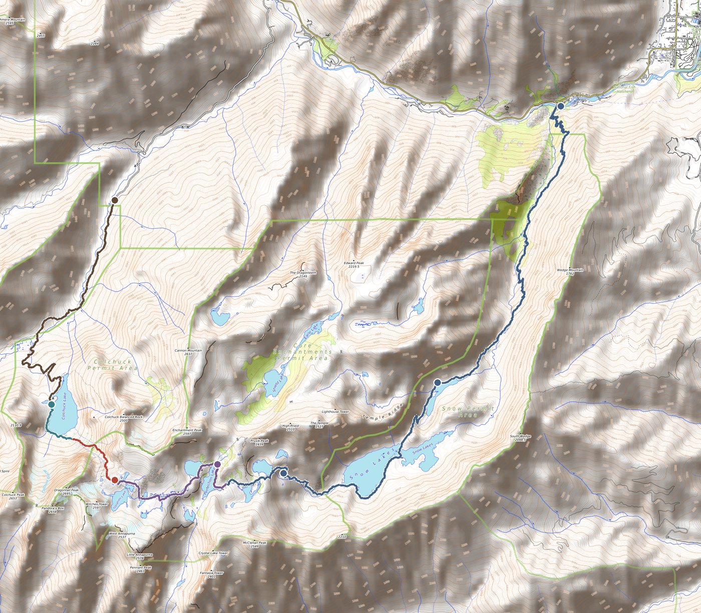
No. 01 · Field Plan

Jeff & Travis hike the Enchantments

A single-push crossing of the Alpine Lakes Wilderness — from Stuart Lake Trailhead, over Aasgard Pass, through the Core, and down the long descent to Snow Creek.

Date Sat, Aug 1
Distance 19.25mi
Gain / Loss +5,500/−7,000
Planned Time 13.5hr
Section I · Terrain

The shape of the day

Nineteen miles with a 1,800-foot vertical wall in the middle. The profile below is measured — USGS elevation data sampled at three-hundred points along the actual GPS track — and color-coded to the five segments you'll move through.

2,000 3,000 4,000 5,000 6,000 7,000 8,000 0 mi 5 mi 10 mi 15 mi Aasgard Pass 7,828 ft Colchuck Nada The Core Elevation (ft)

Elevation profile, USGS 1/3 arc-second DEM. Horizontal axis: trail miles (scaled to match published 19.25-mile distance). Vertical axis: feet above sea level.

The Crux

+2,000 ft in 1.25 miles

Aasgard Pass. Everything before is warm-up; everything after is a long descent.

Section II · The Route

Across the Alpine Lakes

A west-to-east traverse of the Cashmere Crags. Starting from the Stuart/Colchuck trailhead reduces total gain by ~2,600 ft over the reverse direction — and gets the hard climb done while the legs are still cool and fresh.

Topographic relief map of the Enchantments traverse, with colored trail segments overlaid on OpenTopoMap contour basemap

Basemap: OpenTopoMap (© OpenStreetMap contributors, SRTM). Trail geometry: OpenStreetMap. Route overlaid as five colored segments — see legend below.

01 Forest approach 0–4.3 mi · +2,200 ft
02 Colchuck shore 4.3–5.1 mi · flat
03 Aasgard Pass 5.1–6.1 mi · +2,000 ft
04 The Core 6.1–8.4 mi · rolling
05 Snow Creek descent 8.4–19.25 mi · −5,400 ft
Section III · Segments

Five acts

The traverse breaks cleanly into five movements, each with its own character, terrain, and tempo. Times assume a steady pace with modest breaks.

01

Forest approach

4.3 mi · +2,200 ft · 2 hours

Steady forested climb on the Stuart Lake Trail. At mile 2.4, a signed fork — stay left for Colchuck; straight leads to Stuart Lake. A wooden bridge drops you onto a small boulder field; turn right and follow the dirt trail up to the lake. Arrive feeling fresh.

02

Colchuck shoreline

0.75 mi · flat · 30 min

Counter-clockwise around the west shore of Colchuck Lake. The far end opens into a jumbled boulder field — cairns lead across. Aasgard towers dead ahead, Dragontail Peak pyramid to its right. Last easy water refill before the climb.

03

Aasgard Pass

1.0 mi · +2,000 ft · 2 hours

The hard part. Loose scree and hand-over-foot scrambling through a forty-degree grade. Stay left of the larch grove about halfway up — the right side looks tempting but leads into much steeper, impassable terrain with a waterfall. Cairns are the only navigation aid. Multiple false summits. Dragontail Peak's dark pyramid blocks the sky on your right all the way up.

04

The Core Enchantments

2.4 mi · −800 ft rolling · 2–3 hours

The reason you came. A granite-slab plateau scattered with alpine lakes: Isolation, Tranquil, Inspiration, Perfection, Sprite, Leprechaun, Viviane — in that order. The trail is mostly cairn-marked with some wooden posts across the slabs. Hit Lake Viviane no later than 2:30 PM to preserve daylight for the descent. Mountain goats are a near-certainty; larches, ptarmigan, and marmots likely.

05

Snow Creek descent

10.8 mi · −5,400 ft · 6+ hours

The long haul. Technical scramble down bolted rebar steps on wet granite slabs off Lake Viviane, then past Upper Snow, across the dam (maybe wet feet), around Lower Snow, then down to Nada. Tank up on water at Nada — it's the last reliable source.

From Nada, 5.5 miles of relentless exposed switchbacks through shrubland. No shade, no landmarks, just percussion on the quads. The hike's hardest section mentally, not physically.

Section IV · Timeline

Mile markers & thermal plan

Every waypoint, with clock time, trail mile, elevation, and elevation-corrected temperature. Based on a 7:00 AM start from Stuart/Colchuck TH, a 13.5-hour moving-plus-breaks budget, and Leavenworth's climate normal for August 1 (1991–2021).

7:00 AM 0.0 mi Stuart/Colchuck TH Start — fill out free day-use permit 3,399′ 57°F 3,399 ft · 57°F ·
8:00 AM 2.6 mi Mountaineer Creek bridge Stay LEFT at Stuart/Colchuck fork 4,569′ 57°F 4,569 ft · 57°F ·
9:00 AM 4.3 mi Colchuck Lake arrival Filter water. Aasgard visible across. 5,584′ 58°F 5,584 ft · 58°F ·
9:30 AM 5.0 mi Base of Aasgard Cross boulder field, cairns lead up 5,717′ 59°F 5,717 ft · 59°F ·
10:30 AM 5.6 mi Mid-Aasgard (larch grove) Stay LEFT of grove — right leads to cliffs 7,000′ 57°F 7,000 ft · 57°F ·
11:30 AM 6.0 mi Aasgard Pass (apex) 7,828 ft — highest point of hike 7,828′ 57°F 7,828 ft · 57°F ·
12:00 PM 6.4 mi Isolation Lake First lake in the Core. Brynhild in Norse names. 7,739′ 58°F 7,739 ft · 58°F ·
12:15 PM 6.7 mi Tranquil Lake Highest lake in basin (7,803 ft). Freya. 7,566′ 59°F 7,566 ft · 59°F ·
12:45 PM 7.6 mi Inspiration Lake Prusik Peak views from here 7,210′ 61°F 7,210 ft · 61°F ·
1:15 PM 8.0 mi Perfection Lake Rune in Norse. Reflecting waters. 7,105′ 61°F 7,105 ft · 61°F ·
1:45 PM 8.1 mi Sprite & Leprechaun Twin lakes with waterfalls between 7,110′ 62°F 7,110 ft · 62°F ·
2:15 PM 8.4 mi Lake Viviane HARD DEADLINE: leave by 2:30 PM 7,048′ 62°F 7,048 ft · 62°F · end of Core
2:45 PM 9.0 mi Rebar descent Bolted steps on wet granite slab 6,899′ 63°F 6,899 ft · 63°F ·
3:15 PM 9.6 mi Upper Snow Lake Flat walking along lakeshore begins 6,508′ 64°F 6,508 ft · 64°F ·
4:15 PM 10.7 mi Snow Lakes dam Shallow crossing, possibly wet feet 5,438′ 67°F 5,438 ft · 67°F ·
5:15 PM 13.2 mi Nada Lake LAST reliable water. Tank up. 4,944′ 66°F 4,944 ft · 66°F ·
7:00 PM 16.4 mi Snow Creek Wall Look up for climbers on 800ft wall 2,914′ 67°F 2,914 ft · 67°F ·
8:30 PM 19.2 mi Snow Lakes TH FINISH. Return permit envelope. 1,318′ 65°F 1,318 ft · 65°F ·

★  Key decision points. Temperature uses a standard dry-air lapse rate of 3.5°F per 1,000 ft, applied to the hourly valley temperature curve. Actual conditions on the day may vary ±10°F — a heat dome could push the lower descent much hotter.

Section V · Light & Sky

Solar geometry, August 1

Starting at 7 AM gives 13½ hours before sunset. If the hike runs long, another 34 minutes of usable light follows. The 92%-full moon rises at 9:52 PM — late, but bright if needed.

First light 5:05 AM
Sunrise 5:39 AM
Solar noon 1:09 PM
Sunset 8:39 PM
Last light 9:13 PM
Day length 14 h 59 m
Moon phase 92% wax
Moonrise 9:52 PM
Leavenworth climate normal · Aug 1 (1,165 ft)

Typical daily low 60°F at dawn, rising to a high of 83°F around 2–3 PM. August 1 falls squarely in Leavenworth's driest window — a typical day has a 7% chance of precipitation, and 78% of daylight hours are clear or partly cloudy. Humidity is low; winds light (~5 mph).

Section VI · Marginalia

Two things worth knowing

Footnote · Toponymy

The Norse lake names

Many of the Core Enchantments lakes have two names. The official USGS names — Isolation, Tranquil, Inspiration, Perfection, Leprechaun — came out of board rulings in the 1960s. But the unofficial names, still used on some maps and by locals, were given by Bill and Peg Stark, who named the basin for Norse mythology: Lake Brynhild (Isolation), Lake Freya (Tranquil), Lake Rune (Perfection), and the surrounding Valhalla Cirque.

The reason, as Peg Stark explained, was that the landscape felt "as if the Ice Age had just gone off." The official naming rulings adopted a mixture of the two traditions, which is why Aasgard Pass also appears on some maps as Colchuck Pass. Current Forest Service policy precludes adopting new names for features within wilderness areas, so the rest of the Starks' Norse cartography stays unofficial — a quiet second layer over the land.

The basin itself was first named by A.H. Sylvester, a USGS topographer and Wenatchee Forest district supervisor from 1908 to 1931, who came across the unmapped alpine lakes and wrote in a letter: "It was an enchanting scene. I named the group Enchantment Lakes."

Footnote · Fauna

Why the goats follow you

The Enchantments mountain goats have, over decades, learned that hikers' urine is a dense concentrated source of salt — the most reliable sodium source anywhere in the alpine. This has made the local population unusually habituated to human presence. They will stop grazing to watch you, walk toward you, and linger near any spot where a human has recently relieved themselves.

The Forest Service's recommendation: always use the privies provided, which keep waste completely out of reach of prying snouts. If you absolutely must go outside a privy, urinate on exposed rock rather than soil or vegetation — concentrated urine on rock can dilute and wash away, while soil contamination creates a persistent goat magnet that can last for weeks.

A mountain goat trying to drink your urine, as one WTA writer observed, "loses a bit of its wise, dignified mien." Both of you will be happier if the transaction doesn't take place.